 |
||||||||||||||||||||
| : dual sporting the Carrizo Plains. | ||||||||||||||||||||
| This site is East of Santa Maria, California. From Highway 101, take Highway 166 East toward Bakersfield. 15 miles out you'll pass the intersection of Tepusquet Road. Shortly thereafter you'll pass the Pine Canyon Ranger station which is normally closed in Winter months. 10 miles beyond the Ranger station, and 26 miles East of 101 you'll encounter the picturesque Rock Front Ranch. At one time, this ranch house had a sod roof but that has been replaced.
There are two main directions you can take from this location: The Brown Canyon Road (aka Cable Canyon Rd) to the North, and Sierra Madre Road (FS rte 32s13) to the South. Forest Service signs along Highway 166 will indicte whether the area is open for use. During the rainy months, the roads may be closed. |
||||||||||||||||||||
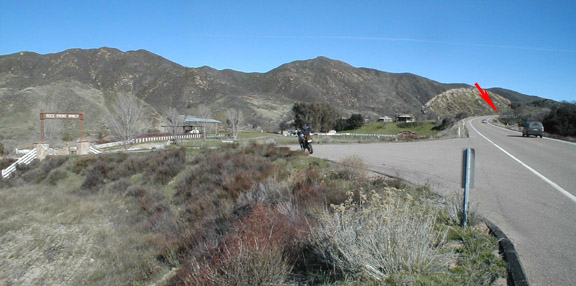 |
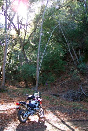
This is the entrance to Rock Front Ranch. Just up the road, at the red arrow in the photo , is the junction with the Sierra Madre Road, which goes to the South (right in this picture). Around the bend in the distance, about 1/4 mile is a very large turnout on the right side that is suitable for leaving your pickup/trailer/van if you didn't ride all the way out. You can also park about 1/2 mile up Brown Canyon road to the left here. | |||||||||||||||||||
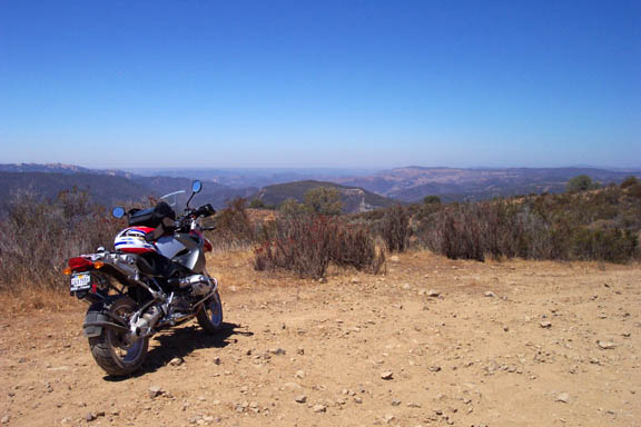
| Most of this road is beginner conditions. There are some spots where the road is rocky, and a couple of steeper sections on the way up and down. The trip across the top, however, is spectacular as you can see from some of the photos below | ||||||||||||||||||||
| This loop trip can be broken down into 4 segments for a total of 47 miles :
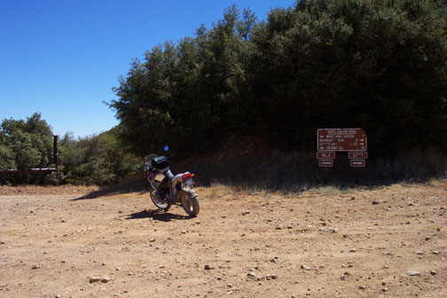
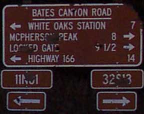
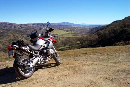
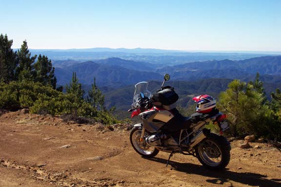
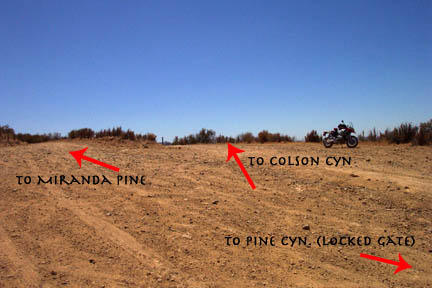
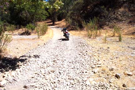
1. 166 ((N35°6.69' , W 120° 5.43'))up to Miranda Pine Camp Ground, approximately 10 miles (dirt). There are plenty of turn-outs that give great views of the Cuyama Valley to the East. Miranda Pine campground is a great spot to stop for a cool drink and to re-group. The area is high, about 4,000 feet of elevation. You'll get a little higher as you go toward Bates Canyon. I've seen deer, bobcat, lions, hawks, eagles, condors and bear in this area up on top. To the South, you can see clear out to the Channel Islands. The campground is about 1/8 mile off Sierra Madre to the Northwest. The intersection to the campground is at N 35° 01.95' W 120° 02.05' If you bail off the Sierra Madre Road to the South at Miranda Pine, you can ride back out to Colson Cyn and on to Tepusquet Road (paved). Taking this route (Pine Cyn Road), ride down and South to approximately N35°00.00' W120°05.89'. There is a Y intersection here. The fork that goes Westerly is Pine Canyon Road and currently dead ends at a locked gate. Take the more Southerly fork. Here the road (NOT MARKED) becomes LaBrea Cyn Road. LaBrea Road offers some great views, becoming flatter after coming down from the Y mentioned above. The road has many rocky creek crossings similar to this one. These will have up to a foot of water in the spring. Follow La Brea Rd to N34°55.02' W120°08.58'. There is a big Forest Service sign there on the East side of the road. Go west across the creek on Colson Canyon Road all the way out to Tepusquet Cyn, N34° 55.41' W120° 13.20' , about 7.8 miles. It's a total of about 25.6 miles from Miranda Pine to Tepusquet road via this route. At Tepusquet, North takes you back to Hwy 166 at a point 17 miles East of 101. South takes you into the Santa Maria Valley past vineyards and wineries. Tepusquet Canyon is loaded with deer. Be extra wary. 2. Miranda Pine to Bates Canyon (FS rte 11n01), 11 miles (dirt). Some sections of the basically flat ridge section are rocky, and should be taken with care or speed : ) Again, plenty of places to stop for photos and wild life watching (if you're not too noisy). Local cattlemen use this road to access their grazing leases, so you can expect some traffic. During dear season (A-zone) hunters will frequent this area. I occasionally ride here in winter, and often don't see a soul. At 11 miles beyond Miranda Pine, you'll come to the Bates Canyon Road intersection to the left. The intersection (photo below) is at N34° 54.98' W119° 54.52'. You CAN go another 8 miles on top up to McPherson Peak. The road is closed there as wilderness section begins. |
||||||||||||||||||||
 |
 |
|||||||||||||||||||
| 3. Bates Canyon to Cottonwood Canyon (dirt/paved) at 166 for 14 miles. Bates Canyon (right) is the route back down to the highway. The first 6 miles are dirt, and parts are steep, but I've done it lots of times in my 2-by pickup. Watch for rock falls in the road. 6 miles down you come to Bates Canyon Campground next to the now abandoned White Oaks Ranger Station. From here, the road is partially paved until you get to the intersection of Cottonwood Canyon and Foothill Road at N34° 58.55' W119° 53.89' . Near this intersection at a location I may develop further for you later (I have to think about this) is the grave site of Nancy Kelsey, the first white woman to come overland to California. She came out from the Midwest in the 1840's at age 18 with a group of 30 men, a little one at her side and 'one in the oven'. Quite a woman, to say the least. From this location, the road is paved all the way to 166. The intersection of Cottonwood Cyn Rd and 166 is at N35° 2.18', W119°52.65' .Expect cattle on the road.
4. Cottonwood Canyon back to Rock Front on 166, about 12 miles. All 2-lane highway. Note.. this area of 166 is frequented by CHP. If you choose, New Cuyama and it's famous Buckhorn Restaurant are only 15 miles farther East. There's gas in town here, and a nice park. Below are some photos of Sierra Madre road. |
 |
|||||||||||||||||||
 |
||||||||||||||||||||
| Bates Canyon, 12/11/04 | ||||||||||||||||||||
| From a site about 3 miles up Sierra Madre road, looking East into the Cuayama Valley
12/11/04 |
||||||||||||||||||||
 |
||||||||||||||||||||
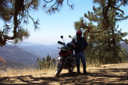
| On top of Sierra Madre road, East of Miranda Pine Campground, looking South toward Solvang.
12/11/04 |
||||||||||||||||||||